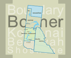
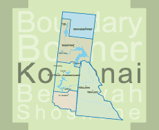
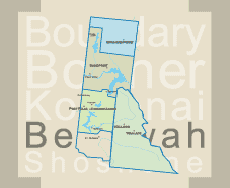
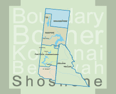


Boundary County - Bonner's Ferry

Bonner’s Ferry, known as Idaho’s Northern International Gateway, is nestled between the Selkirk and Cabinet Mountains on the banks of the Kootenai River.
The present location of Bonner’s Ferry was first utilized by the white man as a camping site in 1859.
The present city of Bonner’s Ferry was created in 1899, most of it still perched on stilts to avoid seasonal spring floods. Bonners’s Ferry became the seat of Boundary County in 1915 when it was separated from Bonner County. It is the only county in the United States that is bounded by two states and a foreign country.
When gold was discovered in the East Kootenays of British Columbia in 1863, thousands of prospectors from all over the West surged northward over a route that became known as the Wildhorse Trail. Edwin Bonner, an enterprising merchant from Walla Walla, Wash., established a ferry in 1864 where the trail crossed the broad Kootenai River. In 1875 Richard Fry leased the business, but the location retained the name of the original founder and later became the town of Bonner’s Ferry. Recently, Idaho’s Governor awarded Bonner’s Ferry the moniker of “Most Friendly Town in Idaho.” This award was based on a poll of tourists that participated in the Idaho Passport program that required travel to all of the State’s Counties.
For inside activities, try your luck at the Kootenai Casino. Bonner’s Ferry truly offers a variety of things to see and do including dining, lodging, shopping, a golf course, skateboard park, public swimming pool, hospital and a museum. Want outdoor activities? Hiking, biking, wildlife viewing, hunting, 4-wheeling and camping abound. Arrangements can be made through the Forest Service to rent a remote lookout for an adventurous and memorable experience. The Kootenai Wildlife Refuge, open year round, except for winter snow obstruction, provides a refuge for waterfowl and wild animals, and is located just west of Bonner’s Ferry. Pack your binoculars and a camera. Check out the Myrtle Creek waterfall, a short distance from the Ranger Station. Back on Hwy 95, the next 16 miles (to junction of Hwys 1 and 95), offer magnificent views of the Kootenai River Valley and the peaks of the Selkirk and Cabinet mountain ranges.
If you go to the left on Hwy 1 at Copeland, watch for the signs to the Westside Road. This road leads to an overlook of the world’s largest hops fields farm operated by Anheuser-Bush. Continue north on Hwy 1 to the border crossing at Porthill (open 7 a.m. to 11 p.m. daily). When crossing the border through Canadian Customs be sure to carry a passport or original birth certificate and birth certificates for your children. You cannot take firearms or pepper spray into Canada. A short drive to Creston leads to the Hwy 3 loop east to the Hwy 95 border crossing at Eastport (open 24 hours daily) and returns you to Idaho.
Traveling south from Eastport on Hwy 95, you encounter a number of fishing and camping locations including the Moyie River just one mile south of the border.
The Moyie is a secret jewel for whitewater paddling enthusiasts and in May and June boasts a superb 15 mile wilderness whitewater run! Fast-paced, frolicking rapids surrounded by a verdant cedar forest and the chance to see moose, osprey and other wildlife make this a superlative adventure. See Outdoor Activities page for more information. Traveling further south on County Road 34, follow the Moyie River on a well-maintained gravel road to the junction with Hwy 2. In the spring and fall, brilliant foliage colors as well as fantastic opportunities to view wildlife, make this an ideal picture taking location. At Hwy 2, turn west and return to Bonner’s Ferry and Sandpoint or head east toward Montana to cross the [7] Moyie River Bridge – said to be the highest bridge in Idaho. At this point there is an overview, where on occasion, you can see water spill over the Moyie River Dam.
If you choose the extended route into Montana, continue going east about 4 miles on Hwy 2. From the Moyie River, it’s 10 miles east to Idaho-Montana state line and the Kootenai National Forest. Three miles east of Troy, Montana, you’ll find the junction of Hwys 2 and 56. Stay on Hwy 2 for about 3.5 miles to reach the Kootenai Falls and The Swinging Bridge. Kootenai Falls was the setting for the filming of the movie, “River Wild.” Return west to the junction and turn south on Hwy 56 to Bull Lake. Past the south end of Bull Lake, turn west on FS Road 398.
Take the 3-mile drive on FS Rd 398 for an awe-inspiring nature trail through the magnificent Ross Creek Cedars Scenic Area where many trees are well over 200 years old. Once you are back on Hwy 56 going south, you will enjoy breathtaking glimpses into the stunning Cabinet Mountains Wilderness Area. Turn west at Hwy 56 & 200 and follow the Clark Fork River via the worthwhile Pend Oreille Scenic Byway to Lake Pend Oreille.
Cabinet Gorge Dam viewpoint is located on Hwy 200 just before the Montana border. The sheer walls of the gorge – carved out by repeating floods over 20,000 years ago – led to the building of this 208-ft. high & 600 ft. long arched dam built in 1952. The impoundment holds back 24 miles of water, all but the last half mile of it is in Montana. Nearby Noxon Reservoir offers excellent fishing opportunities and in fact is one of the top bass fisheries in the state of Montana. About 7 miles past the viewpoint, you will come to the town of Clark Fork.
The lumber & mining town of Clark Fork slumbers peacefully 8 miles east of Hope and is home to a fish hatchery. Want to see deer? Take a short side trip from Clark Fork to the Hope Peninsula where you will almost certainly see grazing herds of whitetail deer and gaggles of Canadian geese. There you will find the David Thompson Game Preserve, named after a remarkable early explorer who established a trading post here called the Kullyspell House, the first European settlement in Idaho, from where he traded with the Indian tribes of the region.
The steep hillside towns of Hope & East Hope offer stupendous views across the northern end of Lake Pend Oreille. Early Chinese laborers on the Northern Pacific Railroad remained after the rails were laid, and a small cemetery at the west end of Hope honors the remains of these early inhabitants. Hope offers RV parks, a marina, camping, fishing and other services. Drive along the lake to the junction of Hwys 200 and 95 and head north on Hwy 95 to return to Bonner’s Ferry. Plan for a stop at nearby Sam Owen Campground for camping, picnicking, swimming or boating.