


 Local Facts
Population: 9,285
Elevation: 2,300
Heyburn State Park was created on Chatcolet Lake in 1908.
St. Joe River is over 120 miles in length with Grade II and III rapids.
This river is the highest navigable river in the world.
Take a deep breath; absorb that smell of pine trees and the great outdoors. Drink in the wide variety of textures, colors, shadows and beauty that only the cacophony of trees, flora and fauna can provide. Listen to the “quiet” of birds calling, water slapping and critters chattering. Rare is the spot in St. Joe Country that you are not immersed in the very best that nature has to offer.
From I-90 take Exit 22 south to the Lake Coeur d’Alene Scenic Byway (Hwy 97) to follow the eastern shore of the lake, the first leg of this loop. The loop may be traveled in a few hours. If you prefer to take a leisurely drive, stop and enjoy the many natural and historical highlights that are unique to the area.
Four miles south on Hwy 97 from I-90, the Beauty Bay Recreation Area offers an excellent spot to picnic, hike, camp or just relax. The Mineral Ridge Hiking Area offers a gentle uphill climb to the top of the ridge for a spectacular view of Lake Coeur d’Alene. Construction began in 1963 for Mineral Ridge, the first recreation site developed by the Bureau of Land Management (BLM) in Idaho. From the hiking trail, expect to see forest plants and other forest inhabitants. Trail guides provide information about North Idaho ecosystems. Camping is available at a USFS campground on Beauty Creek. The five-mile long Caribou Ridge hiking trail up to the Mt. Coeur d’Alene vista starts from the campground.
Further on Hwy 97, at the top of the hill, the Beauty Bay Picnic Site is the perfect spot for a picnic or a stroll on a short nature trail. This small, well-marked recreation site is open during summer months. Taking the Lake Coeur d’Alene Scenic Byway it is less than an hour from the City of Coeur d’Alene to the charming little town of Harrison. This town has become the ideal destination among the fishing, boating, and outdoor enthusiasts who don’t like crowds. Located at the mouth of the Coeur d’Alene River, in the early 1900s Harrison was a main port for big passenger steamers. Gateway to the Thompson Lake Wildlife Refuge where birdwatchers can enjoy nesting osprey, blue heron and waterfowl, Harrison also offers a sandy beach, a protected swimming area, lakeside camping, public docks, boat rentals, restaurants, and accommodations. Harrison’s proximity to the Trail of the Coeur d’Alenes makes it a perfect start and stopping point for the beautiful scenic biking and hiking route. Shopping, restaurants, lodging, and The Crane House Historical Museum which houses the town’s artifacts are just a few of the amenities found in the Harrison area. Shop for fresh produce at the outdoor market in Grange Park every saturday from Memorial Day to Labor Day where crafters and artisans display their wares. Hwy 97 ends south of Harrison at the junction of Hwy 3. Take Hwy 3 north, past the Chain Lakes and back to I-90 or continue south to St. Maries on the White Pine Scenic Byway.
St. Maries is nestled in the beautiful St. Joe Valley where the St. Joe and the St. Maries Rivers meet. Locals call St. Maries the gateway to the “Joe” and the St. Joe portion of the Idaho Panhandle National Forest. Visit the historic Hughes House Museum and Visitor Center for a glimpse into the past and to learn more about the logging town’s colorful history. St. Maries is a hub for many recreational activities, including St. Maries Golf Club, a nine-hole golf course located just one mile east of town. Also a great place to cross country ski. St. Maries offers camping, lodging, small specialty shops as well as a variety of restaurants for the shopper or sportsman.
In the nearby Panhandle National Forest, about 10 miles north of Clarkia or 20 miles south of the St. Joe River, (along Forest Route 321), you can meander through the Hobo Cedar Grove Botanical Area, an excellent half-mile interpretative trail through an ancient cedar grove. Surviving heavy logging and the huge fires of 1910, 1922, 1923 and 1930, these 500-plus year-old cedars now dominate the 240-acre tract. Take a side trip to dig for prehistoric fossils at the Fossil Bowl.
The pretty little Emerald Creek campground, the most southern developed campground in the St. Joe National Forest, offers a comfortable camping experience and convenient access to the Garnet Digging area. Open only during the summer months, for a fee, a visitor can hunt for garnet gems. The Emerald Creek Garnet Area is the only place, outside of India, where Star Garnets can be found.
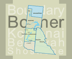
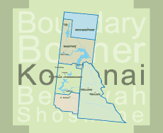
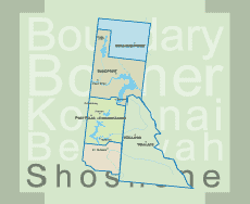
Established in 1908 Heyburn State Park is both the oldest state park in the Northwest and the largest state park (5,500 acres of land and 2,300 acres of water) in Idaho. With 132 campsites in 3 campgrounds, a marina, museum, and beach Heyburn is one of the region’s best kept secrets. Heyburn State Park, six miles from Plummer includes Benewah, Hidden and Chatcolet Lakes and is home to one of the largest nesting populations of osprey in North America. Stop and learn more from the interpretive displays. The South Lake encompasses the area from Heyburn State Park north to Carlin Bay fed by the mouth of the Coeur d’Alene River, is known for its beautiful scenic shores and is ideal for all types of water related activities. Continue on Hwy 5 along the lake and back to the junction of Hwy 95 to the town of Plummer.
The-72 mile trail, Trail of the Coeur d’Alenes between Plummer and Mullan runs through Heyburn State Park. The last part of the Trail of the Coeur d’Alenes to be completed was the historic Chatcolet Bridge, that crosses the St. Joe River as it flows into Lake Coeur d’Alene.
Plummer is the trailhead for the Trail of the Coeur d’Alenes. Plummer is also the headquarters for the Coeur d’Alene Tribe. Just a few miles to the north you’ll arrive in Worley, home to the Coeur d’Alene Casino Resort. Drive north on 95 to return to Coeur d’Alene and I-90.
Another excellent travel choice takes adventurers through the St. Joe River Region. It’s a spectacular drive. Large birds such as bald eagles and ospreys use the towering cottonwood trees along the river as nesting sites so they can be close to the bounty of fish in the river. From St. Maries, go north on Hwy 3, then turn east on the St. Joe River Road towards Avery. Refreshments and recreational services are available along this route. The Shadowy St. Joe and Huckleberry Campgrounds are located on the banks of the St. Joe River, a premier fly-fishing stream. Further east, take a break at the Marble Creek Historic Interpretive Site. Here, you’ll find photos and stories about steam donkeys, iron horses, and the steely loggers who tried to tame the wild Joe. The old pioneer town of Avery, an alternative gateway to the Route of the Hiawatha, where riders can catch a shuttle bus up the mountain from Pearson trailhead seven miles north of town also displays a large interpretive sign which tells the history of the area. The post office building houses a historical museum or tour the old Milwaukee dining car next to the man-made trout pond offering up-close views of the normally elusive trout that populate the St. Joe River. Sixty miles of the St. Joe River above Avery have been declared part of the National Wild & Scenic River System. As you travel the river road along the lower part of the river, you’ll understand why. The upper 29 miles is accessible only by trail.
Returning to I-90 from Avery, it’s 65 miles to St. Regis, Montana. Along this route you’ll find several prime campsites. Keep an eye out for elk, deer, moose, and other wildlife along the way.
Tidbits:
Benewah County has a total area of 784 square miles, of which 777 square miles is land and 7.3 square miles is water.
McCroskey State Park (full name: Mary Minerva McCroskey State Park), was given to the State of Idaho in 1955 by Virgil T. McCroskey, who gradually bought up land endangered by logging. At 5,300 acres this wilderness area is Idaho's second-largest state park. The park lies about 10 miles north of Potlatch, Idaho
McCroskey State Park was given to the State of Idaho in 1955 by a local conservationist, Virgil T. McCroskey, who gradually bought up land endangered by logging and cobbled his purchases into a 4,400-acre parcel. To make the land more attractive to tourists, he cut viewpoints into some of the slopes, built picnic areas, planted flowers, and established a road. The Idaho legislature, however, had serious doubts about the new park – thinking it would not generate enough revenue to justify the loss in taxes – and agreed to accept the gift only if McCroskey, then in his late seventies, would maintain the park at his own expense for the next fifteen years. McCroskey accepted the terms, and lived exactly fifteen more years, fulfilling his obligation to the state of Idaho just weeks before his death in 1970 at age 93.
McCroskey named the park in honor of his mother, a pioneer woman who came to Eastern Washington with her husband and children to establish a homestead near Steptoe Butte; he dedicated it to all pioneer women.